World-class training for the modern energy industry

Workshop on the Seismic Expression of Carbonates (G080)

Tutor(s)

Gene Rankey: Professor, University of Kansas.

Overview

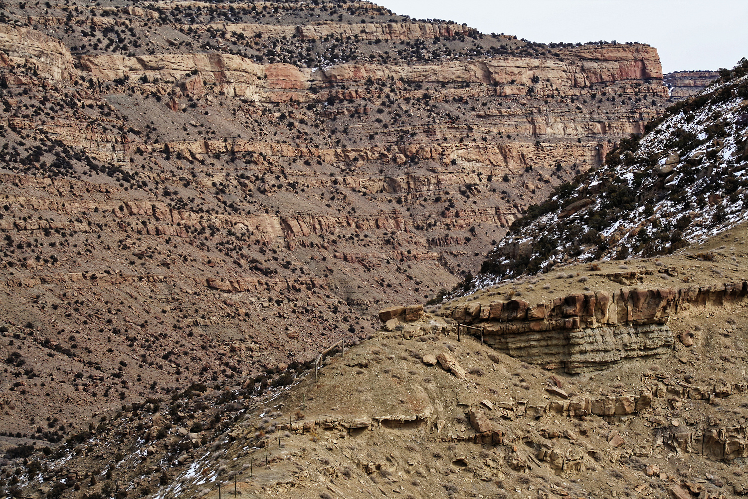
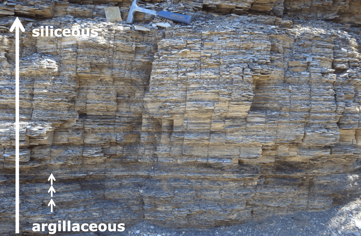
The aim of this course is to provide a general overview of the basic principles of carbonate systems and their expression in seismic data, and to demonstrate its utility for exploration and production. The course will include conceptual models, practical hands-on exercises, and demonstrations of the utility of seismic data and derived products. Key examples will illustrate how seismic stratigraphy and seismic attribute analysis can be used to assess reservoir fairways, subdivide a reservoir, constrain reservoir models, and generate high-resolution, geologically constrained predictions of reservoir systems. An important part of this course will be to draw attention to unique aspects of carbonates and how they might differ from siliciclastic from pore to basin scales.

Objectives

You will learn to:

  1. Establish a working knowledge of carbonate sediment and depositional systems.
  2. Assess carbonate seismic attributes, their general classes, and situations in which different types of attributes are most appropriate.
  3. Evaluate quantitative applications of seismic attributes to map seismic facies and porosity in carbonate reservoirs.
  4. Recognize the expression of carbonates in three-dimensions, how these patterns reflect dynamic stratigraphic evolution, and how these patterns can be related to reservoir trends.
  5. Identify the variation and controls on carbonate reservoir architecture in different system tracts.
  6. Appreciate how carbonate petrophysics influences the seismic response of carbonates.
  7. Appraise the different types of carbonate platform on seismic data and assess the presence of key seismic facies.
  8. Illustrate the seismic geometries of carbonate ramps and rimmed shelves and their possible reservoir character.

Level and Audience

Intermediate. The course is aimed at geologists and geophysicists working on carbonate exploration and production projects. No prior knowledge of carbonates is assumed but participants should have some background in the geosciences.

Duration and Logistics

Classroom version: 2 day classroom course comprising presentations, exercises and case studies. Course notes and exercise materials will be distributed to participants during the course. The manual will be provided in digital format and participants will be required to bring a laptop or tablet computer to follow the lectures and exercises

Virtual version: Four 3.5-hour interactive online sessions presented over four days. Digital course notes and exercise materials will be distributed to participants before the course. Some exercises may be completed by participants off-line.

Onshore Seismic Processing and Imaging (G081)

Tutor(s)

Ron Kerr: Seismic Processing Consultant.

David Kessler: President, SeismicCity Inc.

Overview

This course will introduce the fundamentals of land seismic acquisition including receiver types and their spectrum indication. Land-based seismic data presents unique challenges, and the course will subsequently follow the processes after acquisition to include all the main processing steps of a modern land 3D dataset.

Duration and Logistics

Fundamental. Intended for geoscientists who work with seismic data and are also required to understand land seismic acquisition and processing projects and work with imaging professionals.

Level and Audience

Classroom version: A 2-day classroom course day including a mix of lectures and exercises. The manual will be provided in digital format and participants will be required to bring a laptop or tablet computer to follow the lectures and exercises.

Virtual version: Four 3.5-hour interactive online sessions presented over four days. Digital course notes and exercise materials will be distributed to participants before the course. Some exercises may be completed by participants off-line.

Objectives

You will learn to:

  1. List common onshore seismic source and receiver types and their spectrum indication.
  2. Describe source/receiver line spacing & intervals and their relationship to acquisition footprints and seismic resolution.
  3. Have a clear picture of main processing steps affecting phase and amplitude and understand the concepts of surface-consistency.
  4. Explain in plain language how FWI works and the key factors to velocity model building.
  5. List the types of data used in data processing.
  6. Identify the main components of the seismic wavefield and what they are used for.
  7. Describe the main collections/domains for manipulating seismic data.
  8. Explain the main steps in a processing sequence.
  9. List the main types of noise and describe attenuation methods for these.
  10. Describe the various velocities used in seismic and how to access them.
  11. Identify multiples and explain methods to attenuate them.
  12. Discuss the need for regularization.
  13. Describe the migration process and list the difference between Time/Depth Migrations.

Geological Controls on Production in Unconventional Reservoirs (G052)

Tutor(s)

Bruce Hart: Freelance Geologist and Adjunct Professor at Western University, Ontario.

Overview

This course classifies unconventional reservoirs from a petroleum systems perspective and leads participants through how depositional controls on reservoir architecture and mechanical stratigraphy affect development strategies.

Duration and Logistics

Classroom version: 3 days; a mix of lectures exercises. The manual will be provided in digital format and participants will be required to bring a laptop or tablet computer to follow the lectures and exercises.

Virtual version: Four 4-hour interactive online sessions presented over 4 days. A digital manual and exercise materials will be distributed to participants before the course.

Level and Audience

Fundamental. Intended for subsurface professionals (geologists, geochemists, geophysicists, reservoir-, completion- and drilling engineers) who have some working knowledge of unconventional reservoirs but are looking to understand how multi-disciplinary integration can improve exploration and development decisions.

Objectives

You will learn to:

  1. Describe unconventional reservoirs based on all parts of their petroleum system’s character, and use that knowledge in a predictive way at all steps from exploration to development
  2. Maximize the benefit of common tools for unconventional reservoir characterization.
  3. Define stratigraphic and structural controls on development strategies: landing-zone definition, horizontal vs vertical wells
  4. Develop a common language that can be used to facilitate information exchange between various engineering and geoscience subdisciplines.

Geomechanics for Unconventional Developments (G051)

Tutor(s)

Marisela Sanchez-Nagel and/or Neal Nagel: OilField Geomechanics LLC.

Overview

The course starts with an introduction to geomechanics fundamentals and then aspects relevant to unconventionals are developed, especially as they relate to the effect of fabric and heterogeneity. “Common knowledge” is challenged and popular procedures are presented in the light of geomechanics fundamentals and concepts. Recent topics such as cube developments and frac hits are discussed. This is an in-depth but engaging training course.

Duration and Logistics

Classroom version: 3 days; a mix of lectures (80%) and hands-on exercises and/or examples (20%). The manual will be provided in digital format and participants will be required to bring a laptop or tablet computer to follow the lectures and exercises.

Virtual version: Five 4-hour interactive online sessions presented over 5 days. A digital manual and exercise materials will be distributed to participants before the course.

Interactive questioning and possibly breakout sessions will be utilized to reinforce learnings.

Level and Audience

Advanced. Intended for geoscientists, reservoir and completion engineers and petrophysicists who wish to understand how geomechanics can help them effectively develop their reservoirs.

Objectives

You will learn to:

  1. Understand the fundamentals of geomechanics including stress and strain, pore pressure evaluation, mechanical rock behavior and geomechanical models.
  2. Gain an understanding of conventional fracturing models in unconventional developments and the associated workflow.
  3. Describe the properties of naturally fractured reservoirs including their influence on drilling, stimulation and production.
  4. Perform reservoir quality evaluations including the assessment of poroperm, natural fractures, pressures and mechanical properties as quality indicators.
  5. Characterize shale properties including shale types, brittle versus ductile behavior and geological scenarios for completions.
  6. Assess the influence of the stress field and in-situ pore pressure on hydraulic fracture behavior.
  7. Assess the microseismic response with anisotropic stresses and the use of numerical models for interpretation and characterization.
  8. Characterize the effects of multiple well completions in a fractured rock mass.
  9. Assess the types of hydraulic fracture monitoring including microseismic monitoring.

Cretaceous Lacustrine Carbonate Reservoirs of the South Atlantic (G045)

Tutor(s)

Paul Wright: Independent Consultant.

Overview

This course provides a description of the highly unusual carbonate reservoirs deposited in the Santos Basin (offshore Brazil) during the rift to sag stages of Atlantic opening, and a discussion of the controversies surrounding their origin. Particular emphasis will be given to the Aptian so-called microbialite reservoirs (Barra Velha Formation and equivalents), reviewing both of the main models for their development and evaluating the seismic and sedimentological models. A practical approach to characterizing these complex rock types will be provided. The course will include an introduction to non-marine carbonate systems in extensional settings, as well as a review of the South Atlantic coquina reservoirs.

Duration and Logistics

Classroom version: A 2-day classroom course. The manual will be provided in digital format and participants will be required to bring a laptop or tablet computer to follow the lectures and exercises.

Virtual version: Four 3-hour interactive online sessions presented over 4 days. A digital manual will be distributed to participants before the course. Some reading is to be completed by participants off-line.

Level and Audience

Advanced. Intended for technical staff and managers who are involved in exploration for or exploitation of carbonates along the margins of the South Atlantic, or are interested in furthering their understanding of carbonate reservoirs in general.

Objectives

You will learn to:

  1. Recognize the range of carbonate systems that develop in extensional settings.
  2. Describe the highly unusual and prolific Aptian carbonate reservoirs of the Santos Basin.
  3. Contrast the models for the formation of these chemogenic rocks and discuss their differences.
  4. Evaluate the strikingly different reservoir characteristics that emerge from the two models.

Key Concepts in Clastic Reservoir Performance (G044)

Tutor(s)

Mike Boyles: Retired Shell Oil; Affiliate Faculty, Colorado School of Mines.

Overview

This course presents the concepts and terms used to describe the sedimentology, stratigraphy and structure of clastic units, and introduces the environments of deposition of clastic sediments. The awareness of these topics and their heterogeneities allows participants to understand their role in predicting reservoir performance in exploration projects, in development planning and in managing field performance.

This course presents a stand-alone overview of clastic reservoirs and would be beneficial for any subsurface team member. It also serves to provide the framework for the geologic concepts that are examined in Clastic Reservoirs Field Seminar: Stratigraphic and Structural Heterogeneities That Impact Exploration and Production Reservoir Performance (G012). Attending G044 will allow G012 participants to maximize the benefit of spending time in the field. For a more detailed approach to the subject in the classroom, consider the 5-day Introduction to Clastic Reservoirs: Stratigraphic and Structural Heterogeneities That Impact Performance (G047).

Duration and Logistics

Classroom version: A 1-day classroom course comprising a mix of lectures (75%) and hands-on exercises (25%). The manual will be provided in digital format and participants will be required to bring a laptop or tablet computer to follow the lectures and exercises.

Virtual version: Two 4-hour interactive online sessions presented over 2 days. A digital manual and exercise materials will be distributed to participants before the course. Some reading and an exercise are to be completed by participants off-line.

Level and Audience

Fundamental. This is a refresher course for geoscientists and an overview of geologic basics for reservoir engineers, petrophysicists, managers and support staff.

Objectives

You will learn to:

  1. Understand the basic terminology of sedimentology, stratigraphy and sequence stratigraphy.
  2. Describe key characteristics of eolian, coastal plain, delta and deepwater reservoirs.
  3. Understand how subsurface reservoirs can be divided into flow units that capture key reservoir flow characteristics.
  4. Describe heterogeneities that can impact flow unit properties.
  5. Understand how sequence stratigraphic concepts are applied in a practical and predictive way.

An Introduction to Mudrock Reservoirs: Basin Setting, Stratigraphy, Sedimentology and Rock Properties (G042)

Tutor(s)

Jeff May: Geological Consultant; Affiliate Faculty, Colorado School of Mines.

Overview

The evaluation of shale reservoirs presents a unique challenge: whereas some of the approaches applied are the same as for conventional reservoirs, many new methodologies and tools have been developed for the assessment of this unconventional resource. In this seminar, participants are exposed to the latest concepts of mudrock sedimentation and how it relates to reservoir properties. The development of mudrock successions, including depositional processes and stratigraphic cycles, is highlighted. Goals of the course include:

  • Providing practical techniques for assessing reservoir heterogeneity during play reconnaissance (‘data mining’) and regional evaluation (‘sweet spot’ mapping).
  • Interpreting and correlating well logs within a sequence-stratigraphic framework.
  • Learning what components are fundamental to core description and interpretation, including observations on composition, texture, sedimentary structures and fractures.
  • Developing an understanding of the factors that control reservoir quality: mineralogy, lithologic components, cements, fabric, fractures and pore systems. Methods used to investigate these rock properties also will be discussed.

Duration and Logistics

Classroom version: A 2-day classroom course comprising a mix of lectures (80%) and hands-on exercises (20%). The manual will be provided in digital format and participants will be required to bring a laptop or tablet computer to follow the lectures and exercises.

Virtual version: Four 4-hour interactive online sessions presented over 4 days. A digital manual and exercise materials will be distributed to participants before the course. Some reading and several exercises are to be completed by participants off-line.

Level and Audience

Fundamental. Intended for all subsurface professionals involved in the evaluation of unconventional resources. Geologists, geophysicists, petrophysicists and engineers who want to understand mudrock deposition relative to reservoir properties will benefit from the concepts and techniques presented. Participants should have a basic familiarity with resource plays. Some understanding of depositional processes and sequence stratigraphy is recommended.

Objectives

You will learn to:

  1. Determine the key geologic parameters that affect the attributes of shale reservoirs.
  2. Identify the components of basin analysis required when scoping a new shale play.
  3. Integrate a variety of data types necessary to identify and map optimum drilling locations and targets.
  4. Evaluate the variety of depositional processes and changes in environmental conditions recorded in a shale succession and tie that information back to well log character.
  5. Assess the basic stratigraphic framework of shale reservoirs and understand how systematic vertical changes relate to fabric, composition, texture and, ultimately, reservoir quality.
  6. Interpret and correlate well logs utilizing a sequence stratigraphic framework.
  7. Understand the observations and methodology necessary when describing and interpreting mudrock cores.
  8. Define the key rock parameters that control reservoir quality and mechanical properties.
  9. Describe the latest methodologies of pore-scale imaging for shale evaluation.

An Introduction to Offshore Seismic Data Acquisition (G041)

Tutor(s)

Malcolm Lansley: Consultant Geophysicist.

Overview

Participants will learn the steps necessary to plan successful offshore seismic acquisition projects and will also learn how to work with contractors to ensure that projects are executed safely and according to plan.

Duration and Logistics

Classroom version: A 1-day classroom course comprising a mix of lectures (90%) and exercises (10%). An optional workshop where a client’s project data may be reviewed can be added. The manual will be provided in digital format and participants will be required to bring a laptop or tablet computer to follow the lectures and exercises. Multiple choice quizzes will be utilized to reinforce learnings.

Virtual version: Two 4-hour interactive online sessions presented over 2 days. A digital manual and exercise materials will be distributed to participants before the course. Some reading and several exercises are to be completed by participants off-line. Multiple choice quizzes will be utilized to reinforce learnings.

Level and Audience

Fundamental. Intended for early career geoscientists and technical support staff who routinely work with seismic data and who would like to manage seismic acquisition projects and interact effectively with data acquisition professionals.

Objectives

You will learn to:

  1. Revisit the fundamental principles of seismic wave propagation.
  2. Review seismic vessel and equipment options for data acquisition and logistics in different marine environments.
  3. Understand key project parameters required to design a successful project.
  4. Review the bid tender process and be able to recommend contract specifications.
  5. Outline a management plan for Health, Safety and Environmental compliance.
  6. Appreciate the importance of employing qualified field QC personnel to ensure the successful completion of data acquisition projects.

An Introduction to Onshore Seismic Data Acquisition (G040)

Tutor(s)

Malcolm Lansley: Consultant Geophysicist.

Overview

Participants will learn the steps necessary to plan successful onshore seismic acquisition projects and will also learn how to work with contractors to ensure that projects are executed safely and according to plan.

Duration and Logistics

Classroom version: A 1-day classroom course comprising a mix of lectures (90%) and exercises (10%). An optional workshop where a client’s project data may be reviewed can be added. The manual will be provided in digital format and participants will be required to bring a laptop or tablet computer to follow the lectures and exercises. Multiple choice quizzes will be utilized to reinforce learnings.

Virtual version: Two 4-hour interactive online sessions presented over 2 days. A digital manual and exercise materials will be distributed to participants before the course. Some reading and several exercises are to be completed by participants off-line. Multiple choice quizzes will be utilized to reinforce learnings.

Level and Audience

Fundamental. Intended for early career geoscientists and technical support staff who routinely work with seismic data and who desire to manage seismic acquisition projects and interact effectively with data acquisition professionals.

Objectives

You will learn to:

  1. Revisit the fundamental principles of seismic wave propagation.
  2. Review equipment options for data acquisition and logistics.
  3. Understand key project parameters required to design a successful project.
  4. Review the bid tender process and recommend contract specifications.
  5. Outline a management plan for Health, Safety and Environmental compliance.
  6. Appreciate the importance of employing qualified field QC personnel to ensure the successful completion of data acquisition projects.

Characterization of Clastic Reservoirs: Workflows for Reservoir Evaluation (G035)

Tutor(s)

Rene Jonk: Director, ACT-Geo Consulting and Training; Honorary Professor, University of Aberdeen.

Overview

Reservoir mapping at production scale has to be performed with an understanding of clastic depositional systems, with full integration of core, core-plugs, well logs, seismic and production and engineering data. The variation in reservoir architecture of most common deposition-system morphotypes strongly influences development and production strategies, as well as in mapping techniques for not only the field scale but also to increase chances of finding near-field opportunities. The workshop examines common reservoir facies in transitional-marine to deep water systems, from fluvio-, wave- and tidal-dominated deltas, incised valleys, deep water channel systems and distributary channel lobe systems (deep water fans). Discussions include dimensional data of sand bodies in the different environments and recognition criteria in cores, well logs and seismic. The class will present optimized workflows for reservoir mapping, including the definition of the deliverables that need to be achieved in different business stages, focusing on when, why and how to develop them.

Duration and Logistics

Classroom version: 3 days; a mix of lectures (55%), core observation (10%) and hands-on exercises (35%). The manual will be provided in digital format and participants will be required to bring a laptop or tablet computer to follow the lectures and exercises.

Virtual version: Five 4-hour interactive online sessions presented over 5 days. A printed manual and exercise materials will be distributed to participants before the course and several exercises are to be completed by participants off-line.

Level and Audience

Advanced. This course is intended for geologists, geophysicists and petrophysicists with basic training in sequence stratigraphy and basic clastic facies.

Objectives

You will learn to:

  1. Recognize different environments of deposition (EoDs) in cores, emphasizing typical facies stacking in common transitional marine and deep marine reservoirs.
  2. Classify facies and stacking in typical transitional marine to deep marine EoDs.
  3. Mechanisms for sediment transport in different EoDs and impact on reservoir rock properties.
  4. Integrate core and core plug information in reservoir analysis, tying to well log and seismic data.
  5. Recognize typical log patterns in different depositional systems.
  6. Recognize typical seismic map views and cross-sectional views of sand-rich EoDs.
  7. Apply mapping techniques for well logs and seismic with emphasis on identification of EoDs.
  8. Make pre-drill predictions based on understanding of EoDs and seismic response.
  9. Understand dimensional data for sandbodies in different EoDs
  10. Implement reservoir mapping workflows that emphasize data integration and focus on deliverables in different business stages.