World-class training for the modern energy industry

Characterization, Modeling, Simulation and Development Planning in Deepwater Clastic Reservoirs, Tabernas, Spain (G076)

Tutor(s)

Mark Bentley: TRACS International Consultancy and Langdale Geoscience.

Overview

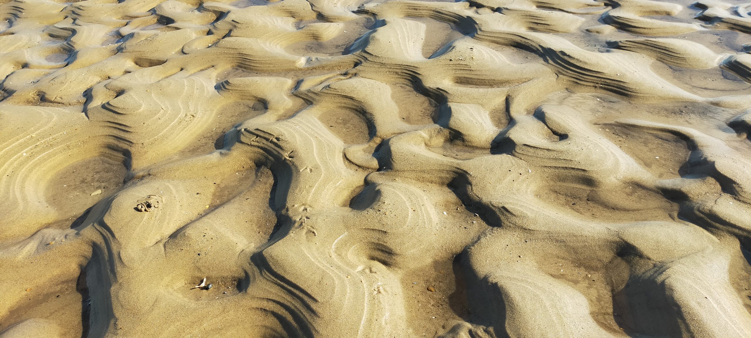
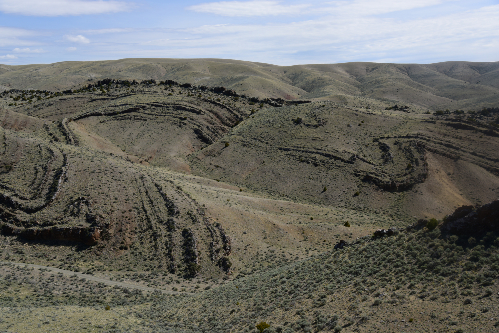
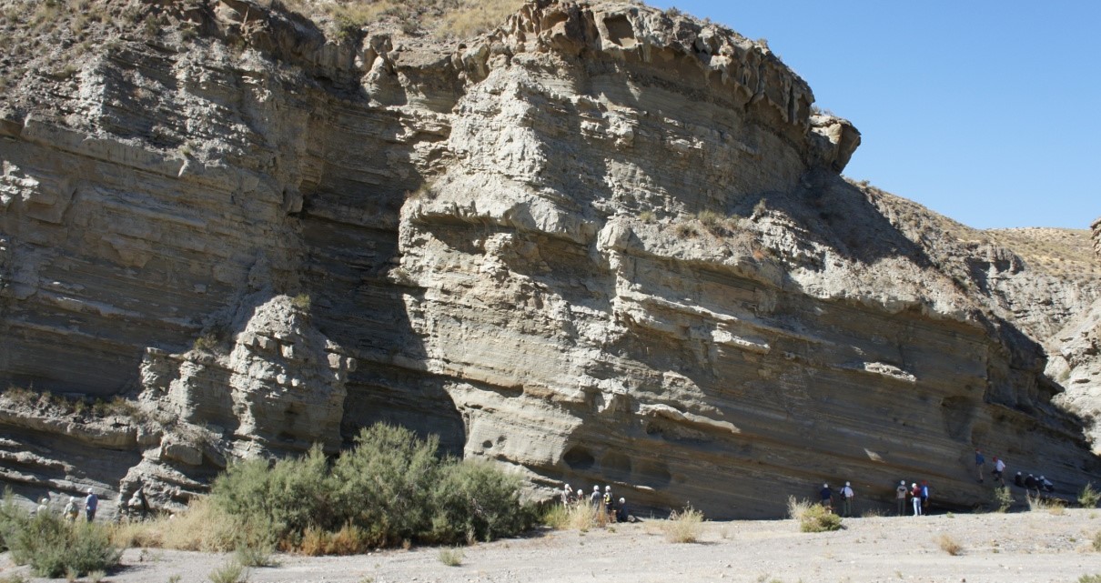
This course is led by a production geologist and reservoir engineer involved in deepwater reservoir development, and is presented as a practical reservoir discussion rather than purely a traditional geological field trip. The objective of this field course is to explore the reservoir modelling and petroleum engineering aspects of deepwater clastic reservoirs. The discussions highlight the linkage from depositional processes to geological architecture and flow heterogeneity in development planning. The Tabernas outcrops are very well exposed and offer examples of sand-rich and debris-flow-dominated reservoirs, high net:gross fan systems and classic mud-dominated facies. In particular, they give excellent insights into the reservoir heterogeneities occurring within apparently continuous ‘sand lobes’ and major channels.

Duration and Logistics

A 7-day field course based in Almeria, Spain, comprising a mix of field activities and exercises. Transport will be by SUV on paved roads and unpaved tracks.

Level and Audience

Advanced. The course is largely aimed at geologists and reservoir engineers working on deepwater developments. The course is best suited to multidisciplinary team of geologists, geophysicists, petrophysicists and reservoir engineers.

Exertion Level

This class requires a MODERATE exertion level. There will be multiple walks of up to 1km (0.5 mile) most days. The longest walk of the class is approximately 2km (1 mile), with an ascent (and descent) of 75m (245 ft). The field area is in Europe’s only desert region and participants should expect high temperatures and an arid working environment. Participants should also be prepared for sudden and heavy rain showers.

Objectives

You will learn to:

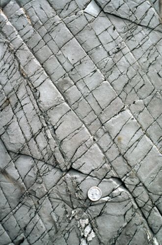
  1. Assess the genetic processes that produce slumps, slides, debrites and high/low density turbidites, and explain why the concept of confinement underpins the description of heterogeneity in deepwater clastic systems.
  2. Evaluate the extent to which pay is under-/over-estimated in mud-rich/sand-rich systems, respectively, and the resulting errors in STOIIP and PI estimation.
  3. Organise a detailed sedimentological description into key reservoir elements and build an architectural model using those elements.
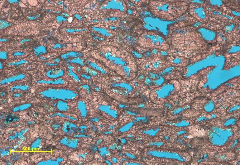
  4. Assess the basic principle of flow in porous media (Darcy) and describe how flow heterogeneity varies in layered and amalgamated clastic systems.
  5. Appraise the contrasting heterogeneities in sand- and mud-rich systems and determine how much detail is required in a reservoir description based on a consideration of fluid type and production mechanism.
  6. Evaluate how kv/kh impacts recovery in typical deepwater clastic architectures; optimally locate a well to optimize sweep for a range of architectural cases.
  7. Judge length scale variations for a typical deepwater clastic system, and discuss how this would be handled in a reservoir modelling and simulation context.

The Essentials of Rock Physics and Seismic Amplitude Interpretation (G075)

Tutor(s)

Eleanor Oldham: Senior Geophysicist, Merlin Energy Resources.

Overview

This course introduces participants to the principles, workflows and limitations of interpreting seismic data using rock physics. The principal topics to be covered include how AVO works, what should the interpreter expect, rock physics inputs for seismic models, rock properties from seismic and rock physics in prospect risking.

Duration and Logistics

Classroom version: A 4-day in-person course, comprising a mix of lectures and interactive learning through worked Excel examples. The course manual will be provided in digital format.

Virtual version: Eight 3-hour live online sessions presented over 8 days, comprising a mix of lectures and interactive learning through worked Excel examples. The course manual will be provided in digital format.

Level and Audience

Fundamental. The course is largely aimed at geoscientists, reservoir engineers and petrophysicists wanting an introduction to the subject of rock physics and seismic amplitude interpretation.

Objectives

You will learn to:

  • Construct a simple AVO model and apply it to seismic interpretation in different AVO settings.
  • Illustrate the characteristics of seismic wavelets and approaches to synthetic well ties with reference to models.
  • Demonstrate the use of rock physics for seismic modelling and Gassmann’s equation in fluid substitution.
  • Tackle a variety of rock physics issues, including fluid substitution in shaly and laminated sands, modelling of tight sands and log editing.
  • Differentiate AVO techniques and practical AVO issues, including the potential for interpretation ambiguity and data quality.
  • Apply band limited impedance with respect to net pay prediction and their limitations.
  • Implement the use of Bayesian update to evaluate probability in inversion and risking.

Seismic Processing Workflows (G072)

Tutor(s)

Rob Hardy: Director, Tonnta Energy Limited.

Overview

This course will provide participants with the skills needed to liaise with specialists and implement workflows for seismic data acquisition and processing. Using modern case histories and basic theory, the course covers fundamentals, established workflows and advanced technology. Participants will use interactive processing tools to improve their understanding of the latest techniques and learn how to apply them effectively and efficiently to meet their objectives.

Duration and Logistics

Classroom version: A 3-day in-person course, comprising a mix of lectures with examples (90%), laptop-based exercises and discussion (10%). The manual will be provided in digital format and participants will be required to bring a laptop or tablet computer to follow the lectures and exercises.

Virtual version: Six 3-hour interactive online sessions presented over 6 days, comprising a mix of lectures, discussion and interactive exercises using case histories to illustrate the basic theory and impact of the techniques discussed. The participants will use a series of web-based software modules to experience the processing options available and learn how to combine the basic tools together to build a flow which meets objectives. A digital manual and exercise materials will be distributed to participants before the course. Some reading and several exercises are to be completed by participants off-line.

Level and Audience

Intermediate. This course is aimed at geoscientists seeking an overview of seismic acquisition techniques and processing methods, and those who wish to liaise effectively with specialists to improve their decision making and deliver objectives. A geophysics refresher is provided but it is helpful if participants have a basic knowledge of seismic acquisition and processing terminology and are actively working with seismic data.

Objectives

You will learn to:

  1. Compare the most common seismic acquisition and processing techniques used in seismic exploration and production, and become more proficient in the terminology used to describe them.
  2. Establish how survey design, earth model building and selection of migration algorithm can affect accuracy of interpretation in depth.
  3. Optimize the impact of seismic processing parameter selection for specific objectives such as amplitude interpretation for exploration and reservoir characterization.
  4. Demonstrate a typical seismic processing workflow covering data preparation, parameterization, noise and multiple suppression, velocity model building, and the imaging process, discussing likely issues at each step.
  5. Compare newer acquisition and processing techniques alongside their potential benefits and pitfalls.
  6. Liaise effectively with specialists, develop workflows and optimize decisions based on quality and cost.

Fundamentals of Seismic Processing (G071)

Tutor(s)

Rob Hardy: Director, Tonnta Energy Limited.

Overview

This course will provide participants with fundamentals needed to liaise with specialists and discuss workflows for seismic data acquisition and processing. Using modern case histories and basic theory, the course covers fundamentals, established workflows and advanced technology. Participants will use interactive processing tools to improve their understanding of the latest techniques, learn how to apply them effectively and efficiently to meet their objectives.

Duration and Logistics

Classroom version: A 2-day in-person course, comprising a mix of lectures with examples (90%), laptop-based exercises and discussion (10%). The manual will be provided in digital format and participants will be required to bring a laptop or tablet computer to follow the lectures and exercises.

Virtual version: Four 3-hour interactive online sessions presented over 4 days, comprising lectures, discussion and interactive exercises using case histories to illustrate the basic theory and impact of the techniques discussed. The participants will use a series of web-based software modules to experience the processing options available and learn how to combine the basic tools to build a flow which meets objectives. A digital manual and exercise materials will be distributed to participants before the course. Some reading and several exercises are to be completed by participants off-line.

Level and Audience

Fundamental. This course is aimed at geoscientists who wish to understand the fundamentals of seismic acquisition techniques and processing methods and to aid more effective liaison with specialists. We start from first principles, but it is helpful if participants have a basic knowledge of seismic acquisition and processing terminology and are actively working with seismic data.

Objectives

You will learn to:

  1. Discuss the most common seismic acquisition and processing techniques used in seismic exploration and production, and become more proficient in the terminology used to describe them.
  2. Outline how survey design, earth model building and selection of migration algorithm can affect accuracy of interpretation in depth.
  3. Recognize seismic processing parameter selection for specific objectives, such as amplitude interpretation for exploration and reservoir characterization.
  4. Discuss a typical seismic processing workflow covering data preparation, parameterization, noise and multiple suppression, velocity model building and the imaging process.
  5. Become aware of newer acquisition and processing techniques alongside their potential benefits and pitfalls.

Introduction to Subsurface Pressures (G085)

Tutor(s)

Richard Swarbrick: Manager, Swarbrick GeoPressure.

Overview

This course introduces attendees to subsurface fracture pressures and fluid pressures, their relevance to subsurface phenomena and assessing risk in deep boreholes. An understanding of pressure is critical for subsurface industries including oil/gas exploitation, carbon sequestration, geothermal energy, waste disposal and hydrogeology, as well as surface aspects such as slope failure. The course teaches the details of what data can be collected and how it can be visualized and interpreted, underpinning more detailed geological and engineering studies.

Duration and Logistics

Classroom version: A 2-day course comprising a mix of lectures, case studies and exercises. The manual will be provided in digital format and participants will be required to bring a laptop or tablet computer to follow the lectures and exercises.

Virtual version: Four 3.5-hour interactive online sessions presented over 4 days. A digital manual and exercise materials will be distributed to participants before the course. The course is rich in exercise material to build up participants’ understanding and confidence in a variety of techniques.

Level and Audience

Fundamental. Intended for all hydrologists, geologists, geophysicists and geomechanical and reservoir engineers. Knowledge of subsurface geology is not required but would be an advantage. Highly relevant to all who are studying the subsurface and especially those engaged in deep drilling and storage.

Objectives

You will learn to:

  1. Understand how fluid pressure and fracture pressure are relevant to subsurface geology.
  2. Evaluate the types of pressure data and measurements possible in the subsurface.
  3. Create plots and maps of pressure data to solve subsurface puzzles (e.g. compartmentalization of reservoirs; distinguishing between hydrodynamic vs hydrostatic flow conditions; and recognition of abnormal pressures).
  4. Appreciate the link between fluid pressure and fracture pressure, and appropriate coupling values.
  5. Recognize how and where pressure data relate to specific events (e.g. slope failure; surface fluid release phenomena; earthquakes and other ground movements).

Modern and Ancient Tide- and Wave-influenced Depositional Systems: Subsurface Uncertainties in Shallow Marine Reservoirs, SE England, UK (G070)

Tutor(s)

Howard Johnson: Shell Professor of Petroleum Geology, Head of the Petroleum Geoscience and Engineering Section, and Director of Petroleum Geoscience, Imperial College London.

Overview

Tide- and wave-influenced marginal marine hydrocarbon reservoirs offer a range of subsurface interpretation and development challenges. This course will use both modern and ancient systems to analyze the architecture, internal characteristics, distribution and reservoir quality of a variety of sand-dominated deposits. Modern deposits of the North Norfolk coastline will be used to explore the range of depositional processes operating and the resultant spatial distribution and internal attributes of potential reservoir units. These will be compared with Lower Cretaceous outcrops preserving a range of tidal-influenced and marine embayment deposits. Focus will be placed on the key development challenges in these marginal marine clastic systems.

Duration and Logistics

A 5-day field course comprising a mix of fieldwork, classroom lectures and practical sessions. Classroom learning and field observations will be supported and reinforced by exercise work. The course will be based in Hunstanton with easy access to the coastal field area. Transport will be by coach.

Level and Audience

Intermediate. The course is intended for geologists and reservoir engineers with a knowledge of petroleum geoscience who are working on marginal marine reservoir systems, particularly those preserving evidence of tidal influence.

Exertion Level

This field course requires an EASY exertion level. The first field day is in a quarry at Leighton Buzzard and involves a walk of about 2km (1.25 miles) to the main quarry face. The remaining field locations on the Norfolk coast are accessed by walks of less than 3.5km (2 miles) along flat sandy beaches and tidal channels that may be muddy and slippery in parts.

Objectives

You will learn to:

  1. Interpret the depositional processes and environments that occur in fluvial-, tide- and wave-influenced clastic coastal depositional systems and relate these to the recognition of their ancient equivalents.
  2. Relate individual modern environmental systems to the larger regional-scale, including modern and ancient marine embayment and coastal barrier systems.
  3. Consider the range of geological controls on the reservoir architecture of clastic coastal deposits and relate this understanding to prediction of reservoir sand presence, geometry and rock properties.
  4. Analyze shallow marine sands in outcrop, with particular focus on internal heterogeneity, including potential permeability barriers and baffles.
  5. Assess the broader scale outcrop setting, in terms of the basinal depositional framework and use this understanding to inform prediction of reservoir distribution.
  6. Place clastic coastal depositional systems into their sequence stratigraphic significance, including addressing reservoir occurrence in transgressive and regressive settings.
  7. Use the modern and ancient examples discussed in the classroom and observed in the field to consider implications for exploration and development, particularly with regards to the subsurface reservoirs of the North Sea.

Prospect Generation, Assessment and Risking (G026)

Tutor(s)

Rene Jonk: Director, ACT-Geo Consulting and Training; Honorary Professor, University of Aberdeen.

Overview

This hands-on course enables attendees to enhance their mapping skills and their critical evaluation of prospects. This course demonstrates how to use play fairway mapping and petroleum system analyses to identify plays and prospects with high potential, even in areas with limited data. Once participants identify prospects, the course outlines how to derive geologically map based, objective inputs for prospect assessment and risking. This stepwise approach creates well-documented results that are used to confidently rank opportunities and make smart business decisions.

Duration and Logistics

Classroom version: 5 days; a mix of classroom lectures and discussion and exercises. The manual will be provided in digital format and participants will be required to bring a laptop or tablet computer to follow the lectures.

Level and Audience

Fundamental. This course is intended for early career geoscientists, reservoir engineers and petrophysicists.

Objectives

You will learn to:

  1. Recall play element definitions and hone mapping skills.
  2. Understand tectonic phases and play types with respect to the history of basin evolution.
  3. Interpret and integrate well and seismic data.
  4. Undertake subsurface mapping of prospects and maturation to drillable status.
  5. Risk and rank prospects.
  6. Identify and assess risks and uncertainties related to geological factors (source, reservoir, seal, trap and preservation).
  7. Evaluate prospect success.

De-risking Carbonate Exploration (G008)

Tutor(s)

Paul Wright: Independent Consultant.

Overview

This is a ‘what you really need to know about carbonates’ course, in order to attempt to de-risk carbonate prospects. Carbonate rocks are complex; however, there are basic principles that provide a framework in which such complexity may be rendered understandable. The course focuses on large scale rules, risks, uncertainties, strategies and workflows, with a heavy emphasis on seismic facies. It does not focus on appraisal or development aspects.

Duration and Logistics

Classroom version: A 4-day classroom course comprising a mix of lectures (75%) and exercises (25%). The manual will be provided in digital format and participants will be required to bring a laptop or tablet computer to follow the lectures and exercises.

Virtual version: Eight 3-hour interactive online sessions presented over 8 days. A digital manual and exercise materials will be distributed to participants before the course. Some reading and several exercises are to be completed by participants off-line.

Level and Audience

Advanced. This course is really aimed at explorationists with at least a basic knowledge of carbonates but will also prove useful to more experienced geoscientists by providing a synthesis of recent advances in understanding carbonate reservoirs, supported by potentially highly practical methodologies for framing uncertainties for reservoir presence.

Objectives

You will learn to:

  1. Frame likely carbonate plays in relation to a given stratigraphic age and basin type.
  2. Identify the main types of carbonate platform as seen from seismic data, de-risk certain types of features and assess the likely presence of key seismic facies.
  3. Evaluate for a given interval and platform type the likely reservoir facies (platform interior, carbonate sands, reefs, slope systems and chalks) and assess the likelihood of reservoir presence.
  4. Understand how the development of primary and secondary porosity has varied through geologic time and how these changes impact upon reservoir quality.
  5. Appreciate the principal modes of formation of dolomites and the predictive uses of different dolomite models.
  6. Understand and identify the diverse origins of palaeokarstic macroporosity, associated risks and the different strategies for developing palaeokarstic reservoirs.

Progressive Deformation in the Arbuckle and Wichita Mountains: Implications for Mid-Continent and Resource Plays, Oklahoma (G083)

Tutor(s)

Kevin Smart: Manager, Earth Science Section, Space Science and Engineering Division, Southwest Research Institute.

David Ferrill: Institute Scientist, Space Science and Engineering Division, Southwest Research Institute.

Overview

This field seminar will explore natural deformation in Paleozoic rocks in and around the Wichita and Arbuckle uplifts in southern Oklahoma. Investigating mechanical stratigraphy and the regional tectonic setting provides the context for understanding deformation features, such as joints, shear fractures, folds, faults and stylolites. Outcrop observations will be tied to the deformation conditions under which they developed, and related to the subsurface (cores, logs and stress data), to illustrate the critical importance of understanding deformation in the subsurface, including both pre-existing natural deformation and as analogs for deformation produced by induced hydraulic fracturing.

Duration and Logistics

A 5-day field course, comprising a mix of field exercises (85%) and classroom work (15%). The course will start in Lawton, Oklahoma, and end near Ardmore, Oklahoma.

Level and Audience

Intermediate. The course is aimed at geoscientists, petrophysicists, reservoir engineers and production engineers working in mechanically layered, deformed rocks in Oklahoma or other relatively gently deformed sedimentary foreland basins. It will be of particular interest to any geoscientists, petrophysicists and engineers working in unconventional reservoirs, including those in the Anadarko Basin.

Exertion Level

This course requires an EASY exertion level. Fieldwork is in southern Oklahoma, where the climate can be variable according to the season. Transportation is by SUVs. Most driving is on black-top roads, and most outcrops are adjacent to roads or within inactive quarries with uneven ground, where long strenuous hikes are not needed to access the exposures.

Objectives

You will learn to:

  1. Identify small-scale deformation features that are common in the SCOOP/STACK plays of the Anadarko basin and other unconventional reservoirs.
  2. Interpret stress conditions and stress evolution from small-scale deformation features.
  3. Characterize mechanical stratigraphy based on lithostratigraphy and rock strength information.
  4. Relate deformation styles to the tectonic setting of southern Oklahoma.
  5. Assess the role of mechanical stratigraphy, stress conditions and pre-existing deformation features on rock behavior, including fracture prediction in unconventional and conventional reservoirs.
  6. Consider, in general terms, the behavior of lithological units under different well completion strategies.
  7. Evaluate geomechanical issues for common petroleum and unconventional resource applications such as well design, borehole stability and hydraulic fracturing.

Salt Tectonics of the Gulf of Mexico (G092)

Tutor(s)

Mark Rowan: President, Rowan Consulting, Inc.

Overview

The objective of this 3-day course is to provide geoscientists with a detailed explanation of those aspects of salt tectonics applicable to the northern and southern Gulf of Mexico (GoM) salt basins. It consists primarily of lectures, with examples from the GoM and other basins, that are supplemented by practical exercises. The emphasis is on fundamental mechanics and processes, structural geometries and evolution, salt-sediment interaction and the implications for hydrocarbon exploration and production.

Duration and Logistics

A 3-day in-person classroom course, comprising a mix of lectures (75%) and seismic exercises (25%). The manual will be provided in digital format and participants will be required to bring a laptop or tablet computer to follow the lectures and exercises.

Level and Audience

Intermediate. The course is intended for geoscientists working the Gulf of Mexico and is also applicable to salt basins around the world.

Objectives

You will learn to:

  1. Understand the implications of layered-evaporite sequences for velocity-model building and seismic interpretation.
  2. Describe how halite differs from other lithologies and how that impacts deformation in salt basins.
  3. Characterize the ways in which extension, contraction and differential loading trigger salt flow and diapir initiation / growth.
  4. Interpret typical salt and stratal geometries associated with salt evacuation and diapirism.
  5. Predict how drape folding around passive diapirs impacts stratal geometries, faulting and reservoir distribution in diapir-flank traps.
  6. Understand why and how allochthonous salt forms and how salt sheets / canopies evolve.
  7. Assess the effects of salt on various aspects of the petroleum system, including trap formation, reservoir presence, hydrocarbon maturation and migration and seal.