World-class training for the modern energy industry

Applied Sequence Stratigraphic Analysis of Well Logs (G014)

Tutor(s)

Jeff May: Geological Consultant; Affiliate Faculty, Colorado School of Mines.

Overview

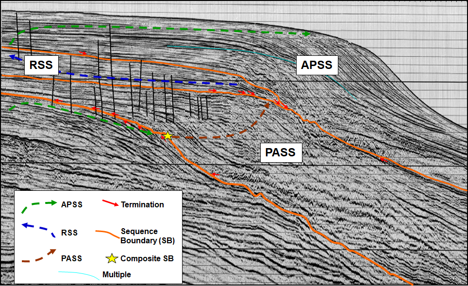
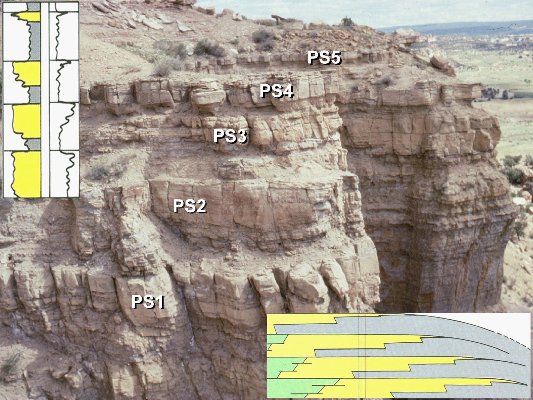
This course offers a practical approach to the sequence stratigraphic analysis of well logs. Lectures and exercises introduce the concepts and terminology of sequence stratigraphy and then apply them to the interpretation and correlation of well logs. Exercises are used to identify significant chronostratigraphic surfaces on well logs and then use the surfaces to construct log correlation sections for a variety of depositional settings. The approach allows for subdividing stratigraphic intervals into meaningful genetic packages, in order to interpret depositional histories and build geologically meaningful maps. Participants will develop the skills necessary to identify and predict new prospects and better subdivide reservoirs.

Duration and Logistics

A 5-day classroom course comprising a mix of lectures (30%), exercises (40%) and core examination (30%). The course is delivered at the Colorado School of Mines in Golden, Colorado, allowing participants access to the school’s inventory of cores. The manual will be provided in digital format and you will be required to bring a laptop or tablet computer to the course.

Level and Audience

Fundamental. This course is aimed at geoscientists to teach them how to interpret well log data, make well-to-well correlations and generate maps in a sequence stratigraphic framework. The content is also suitable for professionals who work with geoscientists, such as petrophysicists and reservoir engineers.

Objectives

You will learn to:

  1. Apply the terminology of sequence stratigraphy.
  2. Identify sequences, systems tracts, sequence boundaries, marine regressive and transgressive surfaces of erosion, and flooding surfaces.
  3. Apply sequence stratigraphic principles in carbonate, continental, shallow marine, deep marine and shale environments.
  4. Generate well-log correlations using sequence stratigraphy concepts and contrast lithostratigraphic and chronostratigraphic correlations.
  5. Apply reservoir-seal-source rock concepts to sequence stratigraphic interpretations.
  6. Create maps of genetically related sequence stratigraphic units.
  7. Predict new stratigraphic prospects or previously untapped reservoir compartments.
  8. Assess the influence of chronostratigraphic surfaces on reservoir quality and flow units.

Shoreline and Shelf Reservoir Systems, Colorado (G013)

Tutor(s)

Mike Boyles: Retired Shell Oil; Affiliate Faculty, Colorado School of Mines.

Overview

This course contrasts two very different clastic shoreline systems by studying two sets of outcrops that were deposited at approximately the same time, about 100km (62 miles) away from each other. One set was deposited by classic river-feed, wave dominated delta systems and the other set had depositional strike-feed systems. The wave dominated deltas are common reservoirs in many basins. However, the less common strike-feed systems have a very different stratal architecture, which can result in the development of significant stratigraphic traps. Participants will develop competence in understanding clastic shoreline and shelf systems and applying sedimentology and sequence stratigraphic concepts to build depositional models and predict facies distributions.

Duration and Logistics

A 8-day field trip comprising a mix of classroom lectures (10%) and field time (lectures and exercises 90%). The course begins in Craig, Colorado, and ends in Steamboat, Colorado. Participants fly in and out of Hayden, Colorado.

Level and Audience

Advanced. Geologists, geophysicists and reservoir engineers working on fluvial / deltaic exploration and production projects. This course is especially relevant for people working reservoirs that were deposited under a tidal influence. The material is presented with minimal jargon so that reservoir engineers can get the maximum benefit of the material.

Exertion Level

This class requires a MODERATE exertion level. Scrambling over rock outcrops and steep sections will be required, but most hikes would be considered moderate. The longest hike is approximately 3.2km (2 miles). Outcrops are at elevations of 1300–2000m (3900–6000 ft). Weather conditions in NW Colorado can vary from warm and dry to cold and wet, with an early fall temperature range of 6–25°C (42–78°F). Transport will be in SUVs on paved and unpaved roads.

Objectives

You will learn to:

  1. Evaluate facies associated with wave dominated deltas, tidal shelf deposits and the often-under-recognized strike-fed tidally influenced shoreline deposits.
  2. Compare depositional dip and strike facies variations within a wave dominated delta complex at the regional scale.
  3. Distinguish deltaic distributaries from incised valley deposits associated with an unconformity.
  4. Identify facies and subsurface geometries of isolated, tidally dominated shelf reservoirs and understand possible links to older shoreline deposits and processes that controlled genesis of these stratigraphic traps.
  5. Use sequence stratigraphic principles to distinguish sequence boundaries, flooding surfaces, transgressive surfaces of erosion and maximum flooding surfaces.
  6. Begin to use the concepts of shoreline stacking patterns to better predict lateral continuity of shoreline systems.
  7. Make interpretations of reservoir systems from subsurface data based on the techniques practiced in the field.

Clastic Reservoirs Field Seminar: Stratigraphic and Structural Heterogeneities That Impact Reservoir Performance, Colorado and Utah (G012)

Tutor(s)

Mike Boyles: Retired Shell Oil; Affiliate Faculty, Colorado School of Mines.

Overview

The course investigates world-class outcrops to introduce all subsurface disciplines to a wide spectrum of stratigraphic and structural features commonly found in exploration and production. An active learning technique encourages participants to make initial observations and interpretations before group discussions. Lectures and exercises provide an awareness of reservoir architecture in a variety of stratigraphic and structural settings while outcrops demonstrate field- and reservoir-scale structural heterogeneities. Depositional environments studied include deltaic, eolian, fluvial, turbidites, tidal, lacustrine and coastal plain. Emphasis is placed on understanding flow characteristics (i.e. connectivity, Kv, Kv/Kh). A practical approach to using sequence stratigraphic concepts is also presented.

Duration and Logistics

A 6-day field course comprising a mix of classroom lectures (10%) and field exercises (90%). The course begins and ends in Grand Junction, Colorado, and visits outcrops in Utah and Colorado.

Level and Audience

Fundamental. This course is presented with minimal jargon so that non-geoscientists, such as reservoir engineers and petrophysicists, get the full benefit of the course. However, it would be particularly suitable for geoscientists working on fluvial/deltaic exploration and production projects, to show how common stratigraphic and structural variations can impact reservoir performance.

Exertion Level

This class requires a MODERATE exertion level. Scrambling over rock outcrops and steep sections will be required, but most hikes would be considered moderate. The longest walk is approximately 4.8km (3.2 miles). Outcrops are at elevations of 1200–2500m (4000–8200 ft). Weather conditions in NW Colorado and eastern Utah can vary from warm and dry to cold and wet, with an early fall temperature range of 5–23°C (41–73°F). Transport will be in SUVs on black-top and unpaved roads.

Objectives

You will learn to:

  1. Divide subsurface reservoirs into flow units that capture key reservoir flow characteristics and heterogeneities at a variety of reservoir model scales.
  2. Communicate and discuss flow unit properties between subsurface team disciplines.
  3. Understand detailed facies analysis within deposits of wave dominated deltas, fluvial dominated deltas, fluvial systems, tidal / estuarine, eolian and turbidites.
  4. Recognition of key facies in cores and logs.
  5. Use key sequence stratigraphic concepts in a practical and predictive way.

Core Facies Analysis of Conventional and Resource Plays: Lessons from the Mowry and Niobrara Petroleum Systems, Powder River Basin (G011)

Tutor(s)

Gus Gustason: Senior Geologist and Geoscience Advisor, Enerplus Resources.

Richard Bottjer: President, Coal Creek Resources; Research Associate, Denver Museum of Nature and Science.

Overview

This core-based facies analysis course will use the petroleum system of the prolific Powder River Basin to develop realistic depositional models and sequence stratigraphic frameworks that can be used to better predict the extent and continuity of unconventional resources. Demonstrations will introduce participants to core handling, description and data integration techniques. Lectures and exercises will re-familiarize participants with lithofacies and facies associations and will describe applications of core-facies analysis to reservoir characterization of siliceous and calcareous mudstones, muddy sandstones and sandstones. Cores will be from the Powder River Basin, but learnings may be applied to resource plays in other basins.

Duration and Logistics

A 5-day classroom course comprising a mix of classroom lectures (25%) and core description exercises (75%) at the USGS Core Research Center, Lakewood, CO. The manual will be provided in digital format and you will be required to bring a laptop or tablet computer to the course.

Level and Audience

Fundamental. This course is intended for entry-level through mid-career geoscientists, reservoir engineers and petrophysicists who want to extract maximum value from cores, in order to improve exploration play analysis and reservoir characterization of both conventional and unconventional resources. Participants should have a basic knowledge of clastic and carbonate sedimentology and stratigraphy.

Objectives

You will learn to:

  1. Identify the important physical and biological parameters of core, including sedimentary structures, biogenic structures, significant surfaces and diagenetic textures. We will examine siliceous and calcareous mudstones, muddy sandstones and sandstones.
  2. Calibrate core descriptions with wireline log data.
  3. Evaluate source rock potential of mudstones using elemental chemistry data (XRF), TOC, RockEval (Vre) and vitrinite reflectance (Vro) data.
  4. Integrate routine core analysis and/or unconventional shale and tight rock analysis with core descriptions to better understand the controls on porosity and permeability.
  5. Identify basic structural features in cores, such as faults and fractures, and relate them to mechanical stratigraphy, in situ stresses and borehole stability issues.
  6. Develop a sequence stratigraphic framework from core descriptions and wireline log data.
  7. Compare reservoir characteristics with production performance to identify target zones for horizontal well placement.
  8. Discretize core descriptions for core-to-log facies analysis and reservoir modelling input.

Interpretation and Analysis of Normal Fault Systems for Trap Analysis and Reservoir Management, Moab, Utah (G006)

Tutor(s)

Bob Krantz: Consulting Geologist and Adjunct Professor, University of Arizona.

Peter Hennings: Consulting Geologist and Research Scientist and Lecturer, UT Austin, Texas.

Overview

Trap analysis for exploration risking and field management requires complete 3-D characterization, especially where faults are critical elements. The ability of faults to seal and leak can vary in space and over geologic and field management timeframes. Explorationists and development geologists must understand fault characteristics, integrate appropriate data and perform specific analyses when working with faulted reservoirs. The Moab fault system and surrounding geology provide exceptional examples of trap-scale structures with fault zone characteristics that vary depending on offset and juxtaposed rock type, which are documented to have both sealed and leaked over geologic time in patterns that are clearly expressed. Reframing these outcrops to subsurface application is immensely valuable in understanding static and dynamic reservoir behavior.

Duration and Logistics

A 6-day field course comprising a mix of classroom lectures (30%), practical exercises (20%) and field visits to some of Earth’s best-exposed and thoroughly studied outcropping fault systems (50%). The manual will be provided in digital format and you will be required to bring a laptop or tablet computer to the course. Laminated posters will be used extensively in the field for annotation and discussion. The course is based in Moab, Utah, with participants arriving in and departing from Grand Junction, Colorado.

Level and Audience

Advanced. This course is intended for geoscientists and reservoir engineers who work with layered faulted reservoirs. Participants would benefit from having a basic familiarity with structural geology.

Exertion Level

This class requires a MODERATE exertion level. The fieldwork will involve walking up and down slopes over rough ground. There will be walks of up to 1.6km (1 mile) on most days, the most strenuous being an ascent (and descent) of 60m (200 ft) over rocky ground as part of a 3.2km (2-mile) walk. The altitude of the field area ranges from 1200–1750m (4000–5800 ft), which may lead to unexpected shortness of breath for some. The weather should be pleasant with typical highs of 27°C (80°F) in the fall, but early morning temperatures may be below 5°C (40°F) on some days. Transport will be by mini-van or SUV on paved and graded dirt roads.

Objectives

You will learn to:

  1. Understand how normal faults form, displace and link in 2-D and 3-D.
  2. Understand how fault systems evolve over geologic time.
  3. Characterize controls on mechanical stratigraphy.
  4. Identify fault zone deformational fabrics and mechanics.
  5. Understand static and dynamic fault seals, fault permeability and seal effectiveness.
  6. Develop reservoir compartmentalization models.
  7. Predict fault reactivation likelihood for application to seal failure and induced seismicity.
  8. Apply 3-D fault framework interpretation methods.

Sequence Stratigraphy of the Permian Basin, Texas and New Mexico (G002)

Tutor(s)

Rene Jonk: Director, ACT-Geo Consulting and Training; Honorary Professor, University of Aberdeen.

Overview

This field course is designed for geoscientists and engineers exploring and developing plays in mixed carbonate-siliciclastic systems; it is relevant to those working in the Permian Basin. The course will enhance each participant’s ability to distinguish depositional facies and play elements, based on seismic features, stratal geometries, sequence stratigraphy, diagenetic changes impacting reservoir quality and depositional models. Subsurface data from the Permian Basin, including seismic, well logs and cores, will be used to establish a sequence stratigraphic framework for the basin, with emphasis on the prediction of play element presence and quality, both for conventional and unconventional resources, including discussions on production behavior and strategies.

Duration and Logistics

A 5-day field course; a mix of field activities (60%) and classroom lectures and exercises (40%), with long days (typically 10 hours). The course begins and ends in El Paso, Texas. The first night is spent in El Paso; subsequent nights are spent in Carlsbad, New Mexico.

Level and Audience

Advanced. This course is intended for geoscientists, petrophysicists, engineers and managers who are seeking a comprehensive examination into the seismic stratigraphy of the Permian Basin.

Exertion Level

This class requires a MODERATE exertion level. Fieldwork is in west Texas and southeast New Mexico, where the weather is arid and usually hot, although cold and wet weather is possible in the spring and fall when daily temperatures range from 5–25°C (40–80°F). The course includes walks of a moderate length (up to 3.2km/2 miles) with an ascent of 305m (1000 ft), frequently over very steep and uneven ground. Transport on the course will be by mini-van. Most of the driving is on black-top roads, with some driving on graded dirt roads.

Objectives

You will learn to:

  1. Analyze exposures of carbonate shelf and ramp to siliciclastic basinal systems, in order to relate depositional facies to seismic scale geometries and sequence stratigraphy.
  2. Examine seismic scale outcrop geometries, document outcrop facies and demonstrate similarities to productive intervals in the Permian Basin.
  3. Understand how subaerial exposure, marine diagenesis and early near-surface dolomitization can affect ultimate reservoir porosity and permeability and overall reservoir geometry in subsurface.
  4. Assess changes in carbonate facies and relate these changes to depositional environments.
  5. Apply Walter’s Law and chronostratigraphic principles in core, well log and seismic interpretation, and relate to prediction of play elements and best productive intervals for unconventional resources.
  6. Analyze sequence stratigraphy for carbonates and mixed carbonate-clastic depositional systems.
  7. Interpret carbonate sequence stratigraphic patterns from outcrop, well log and seismic data.

Sequence Stratigraphy and its expression on Seismic, Logs and Cores (G001)

Tutor(s)

Rene Jonk: Director, ACT-Geo Consulting and Training; Honorary Professor, University of Aberdeen.

Overview

The application of sequence stratigraphy allows for the geologic interpretation of core, well log, seismic and outcrop data to predict play elements, presence and quality before drilling. This course introduces sequence stratigraphy and presents workflows to describe, correlate and map strata. The terminology of surfaces, systems tracts, sequence sets and stratigraphic hierarchy will be described and then applied to subsurface data exercises in non-marine, shallow marine and deep marine depositional settings. The emphasis will be on the recognition and mapping of play elements from exploration to production scales.

Duration and Logistics

Classroom version: A 4-day course comprising a mix of classroom lectures and discussion (50%), and exercises (50%). The manual will be provided in digital format and participants will be required to bring a laptop or tablet computer to follow the lectures and exercises.

Virtual version: Ten 3-hour interactive online sessions presented over 5 days. A digital manual and hard-copy exercise materials will be distributed to participants before the course. Some reading and several exercises are to be completed by participants off-line.

Level and Audience

Intermediate. This course is intended for geoscientists (reservoir modellers, seismic interpreters, sedimentologists), reservoir engineers and petrophysicists who want to understand and apply the concepts of sequence stratigraphy.

Objectives

You will learn to:

  1. Apply the basic terminology of sequence stratigraphy.
  2. Contrast the various approaches to sequence stratigraphy.
  3. Apply the concept of facies, facies stacking and shoreline trajectory to define parasequences, surfaces and system tracts.
  4. Evaluate main controls on depositional sequences in non-marine, shallow marine and deep marine environments.
  5. Assess and interpret cores, well logs and seismic lines to characterize and map hydrocarbon play elements in different settings.
  6. Implement sequence stratigraphic methods to predict play element presence and quality on seismic data.
  7. Describe the Accommodation Succession Method and Sequence Stratigraphy Hierarchy.
  8. Apply chronostratigraphic techniques.