Tutor(s)
Rene Jonk: Director, ACT-Geo Consulting and Training; Honorary Professor, University of Aberdeen
Overview
This hands-on course enables attendees to enhance their skills and critical evaluation of all aspects related to pressure, trap and seal evaluation workflows. This includes understanding and predicting fluid pressure, retention of hydrocarbon fluids and column heights, and reservoir connectivity and compartmentalization. Fluid pressure is evaluated from first principles, downhole measurements (mudweights, RFT/MDT data) and estimated from porosity-effective stress relationships. We make estimations of mechanical seal capacity ranges using Leak off Test data and fundamental elastic rock properties. Capillary seal attributes are estimated from core measurements and calibrated against buoyancy pressure estimates from the crests of oil and gas fields. The fundamental techniques developed in the first two days of the course are applied across a variety of case studies in various modules, including aspects of oil versus gas prediction techniques in exploration, reservoir connectivity evaluation in a faulted reservoir and seal risking workflows for stratigraphic traps.
Duration and Logistics
Classroom version: This course can be customized for a 3 or 4-day delivery, depending on which of modules 5, 6, 7 and 8 are of most interest. It is also possible to include client data or problems to substitute classroom exercise time with discussion time on actual client datasets and problems. The mix of classroom lectures and discussion (50%), and hands-on exercises with subsurface datasets (50%) allow for an interactive and deeply applied learning experience. The lecture materials will be provided in digital format. Participants can bring a laptop or tablet computer to follow the lectures and exercises using digital provided formats. Exercise manuals will be printed in 11×17 format for each student to enhance learning by interpreting using pencil on paper.
Level and Audience
Fundamental. This course is intended for early to intermediate-experience career geoscientists (0-10 years experience), reservoir engineers and petrophysicists who want to understand the fundamental controls on prospect and field pressure, trap-seal, connectivity and compartmentalization, including seal risking worflows and pre-drill predictions of fluid type, column height and pressure.
Objectives
You will learn to:
- Describe trap-seal attributes of prospects in a consistent manner (crest, spill points, seal and fault-seal controls).
- Understand the controls on subsurface fluid pressure and the methods used to describe and predict subsurface fluid pressure.
- Describe and quantify mechanical seal capacity of various seal types relative to hydrocarbon liquids and gases using field data, wireline logs and core attributes.
- Describe and quantify capillary seal capacity of various seal types relative to hydrocarbon liquids and gases using field data, wireline logs and core attributes.
- Understand various controls on hydrocarbon-water contact distributions, including fault-seal, hydrodynamic tilting, reservoir quality controls on saturation.
- Make predictions of oil versus gas column heights for multiphase petroleum systems in exploration settings.
- Make predictions of reservoir connectivity and compartmentalization in faulted reservoirs in appraisal and field development settings.
- Use seal risking workflows to high-grade portfolios of stratigraphic trap prospects, including both deep-water and shallow-water clastic settings.

Tutor(s)
Zane Jobe: Research Professor, Colorado School of Mines and the Director of the Geology Center of Research Excellence (CoRE).
Andrea Fildani: Professor at University of Naples Federico II
Overview
This course will explore a range of outcrops in central California to study topics inherent to the energy transition. Participants will be introduced to the tectonic setting of Western North America that provides opportunities for geothermal energy production, carbon sequestration (both mineralization and pore-scale trapping) and additionally, natural hydrogen exploration. Participants will learn how to characterize the locations of potential projects and explain the key geological factors that affect these and their feasibility.
Duration and Logistics
A 7-day field course based in Sacramento, California. Training will take place through in-class presentations, field observations, printed exercises and discussions in the field. Transport will be by coach.
Exertion Level
The field component of this course requires an EASY exertion level. There will be short hikes to outcrops mostly on flat to gently sloping terrain and gravel tracks. The climate in California during the spring and fall is variable with temperatures from 50°F (10°C) to hot and dry up to 100°F (38°C).
Level and Audience
Fundamental. The course is intended for a variety of professionals working in the energy transition including those responsible for policy on energy, regulators, energy sector investors and also those working on conservation. The course would also be suitable for geoscientists interested in a broad overview of energy transition topics.
Objectives
You will learn to:
- Evaluate the regional tectonic framework and evolution for prediction of energy transition opportunities.
- Describe regional geothermal systems and understand their relationships to tectonic evolution.
- Analyze ultramafic rocks that are targeted for CO2 mineralization studies and natural hydrogen exploration.
- Compare outcrop analogues to subsurface data for carbon sequestration in sedimentary rocks from several depositional environments.
- Characterize the locations of potential projects and explain the key geological factors that affect these and their feasibility.
Tutor(s)
Rene Jonk: Director, ACT-Geo Consulting and Training; Honorary Professor, University of Aberdeen
Overview
This hands-on course enables attendees to enhance their skills and critically evaluate all aspects of hydrocarbon charge, including source presence, maturation, migration, commodity type and timing. Lectures and exercises focus on characterization and prediction of hydrocarbon charge adequacy using core, well log and seismic data. Global examples, covering a range of basin and depositional settings, will be discussed and used in the exercises.
Duration and Logistics
Classroom version: A 3-day course comprising a mix of classroom lectures and discussion (50%), and hands-on exercises with subsurface datasets (50%). The lecture materials will be provided in digital format and participants will be required to bring a laptop or tablet computer to follow the lectures and exercises. Exercises manuals will be printed for each student to enhance learning by interpreting using pencil on paper.
Level and Audience
Fundamental. This course is intended for geoscientists, reservoir engineers and petrophysicists who want to understand the basic concepts of petroleum systems.
Objectives
You will learn to:
- Characterize source rock presence from cores, well logs and seismic and learn to predict source adequacy and risk from first principles.
- Understand the controls on source rock maturation and describe fundamental controls on maturation and maturation timing using burial history charts.
- Assess the fundamental controls on hydrocarbon migration and apply the principles of primary and secondary migration to predict hydrocarbon charge pathways and risk migration adequacy for plays and prospects.
- Assess commodity implications from source rock type and maturity.

Tutor(s)
Douglas Paton: Director, TectoKnow.
Overview
The workshop will be practically based, supplemented by a number of group thought experiments. It will cover an introduction to the fundamentals of structural geology and its impact on hydrocarbon distribution and prediction. It will then outline, with examples, the essential geometric components expected in normal faults / rift basins, reverse faults / contractional environments, inversion / multi-phase settings, and salt and strike-slip influenced systems.
Duration and Logistics
Classroom version. A 4-day course comprising a mix of lectures, case studies and exercises. The manual will be provided in digital format and participants will be required to bring a laptop or tablet computer to follow the lectures and exercises.
Level and Audience
Fundamental. The course is aimed at new hires who need a thorough introduction to the fundamentals of structural geology.
Objectives
You will learn to:
- Understand the fundamental importance of structural geology in modelling the subsurface.
- Appreciate the concept of structural styles and why it is essential to aid the interpretation of subsurface and outcrop data.
- Assess input data required for resource modelling and appreciate its limitations.
- Apply relevant and appropriate models to areas of limited data or zones of complexity and capture the implications of the inherent uncertainty.
- Apply relevant techniques and understanding to enhance resource prediction in extensional, compressional and multi-phase settings, including salt.
- Appreciate the importance of developing a structural robust understanding for any energy transition resource model.
Tutor(s)
Eric Gaucher: CEO, Lavoisier H2 Geoconsult and RockyH2.
Jean Gaucher: Development Officer, Lavoisier H2 Geoconsult.
Overview
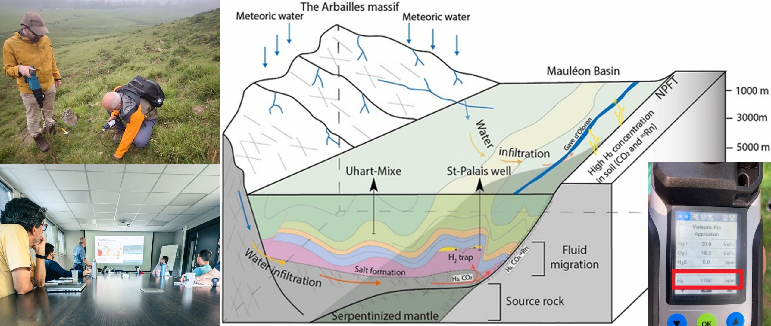
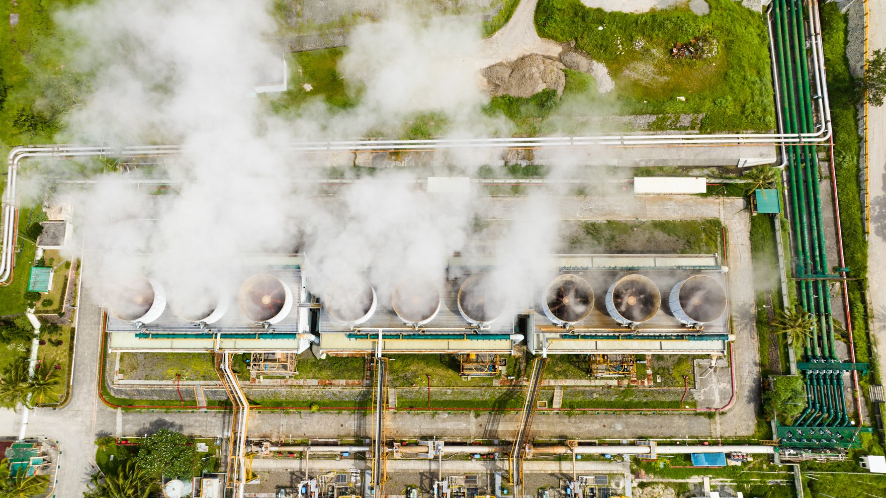
The last few years has seen a growing interest in natural hydrogen accumulations. We know that there are a variety of processes that can lead to hydrogen being produced in the Earth’s crust but there is much still to understand about these, how much is perhaps present in subsurface stores and where these accumulations are. Commercial exploitation will also need to assess the engineering challenges for extracting this hydrogen and ultimately how best it can be utilised as part of the changing face of our modern energy landscape. This course will give an integrated view on the economic, strategic and scientific aspects of natural hydrogen exploration and its perspectives.
Duration and Logistics
Virtual version: Four 3.5-hour online sessions presented over four days comprising a mix of lectures, exercises, case studies and discussion. The course manual will be provided in digital format.
Fieldtrip version: A 5-day field course located in Pau, France with a focus on the geological aspects of natural hydrogen.
Level and Audience
Fundamental. The course is largely aimed at geologists interested in natural hydrogen occurrences but the trainers able to adapt the level of the course to the requirements of the attendees.
Exertion Level
This class requires and EASY exertion level. Travel is by small coach and there are hikes of less than 10 minutes in duration (less than 1 km) on well-graded terrain in the foothills of the Pyrenees.
Objectives
You will learn to:
- Evaluate the different types of hydrogen and the origins of natural hydrogen.
- Characterise the strategies for the exploration of natural hydrogen.
- Clarify and organize the different technical steps of a natural hydrogen exploration programme.
- Appraise the geological, geochemical and geophysical tools that can be used for natural hydrogen exploration.
- Assess the co-production of natural hydrogen with geothermal resources, Helium and the mining industry.
- Assess the techno-economic evaluation of natural hydrogen.

