World-class training for the modern energy industry

An Introduction to Clastic and Carbonate Depositional Systems (G064)

Tutor(s)

Jon Noad: Senior Palaeontologist at Stantec and President of Sedimental Services.

Overview

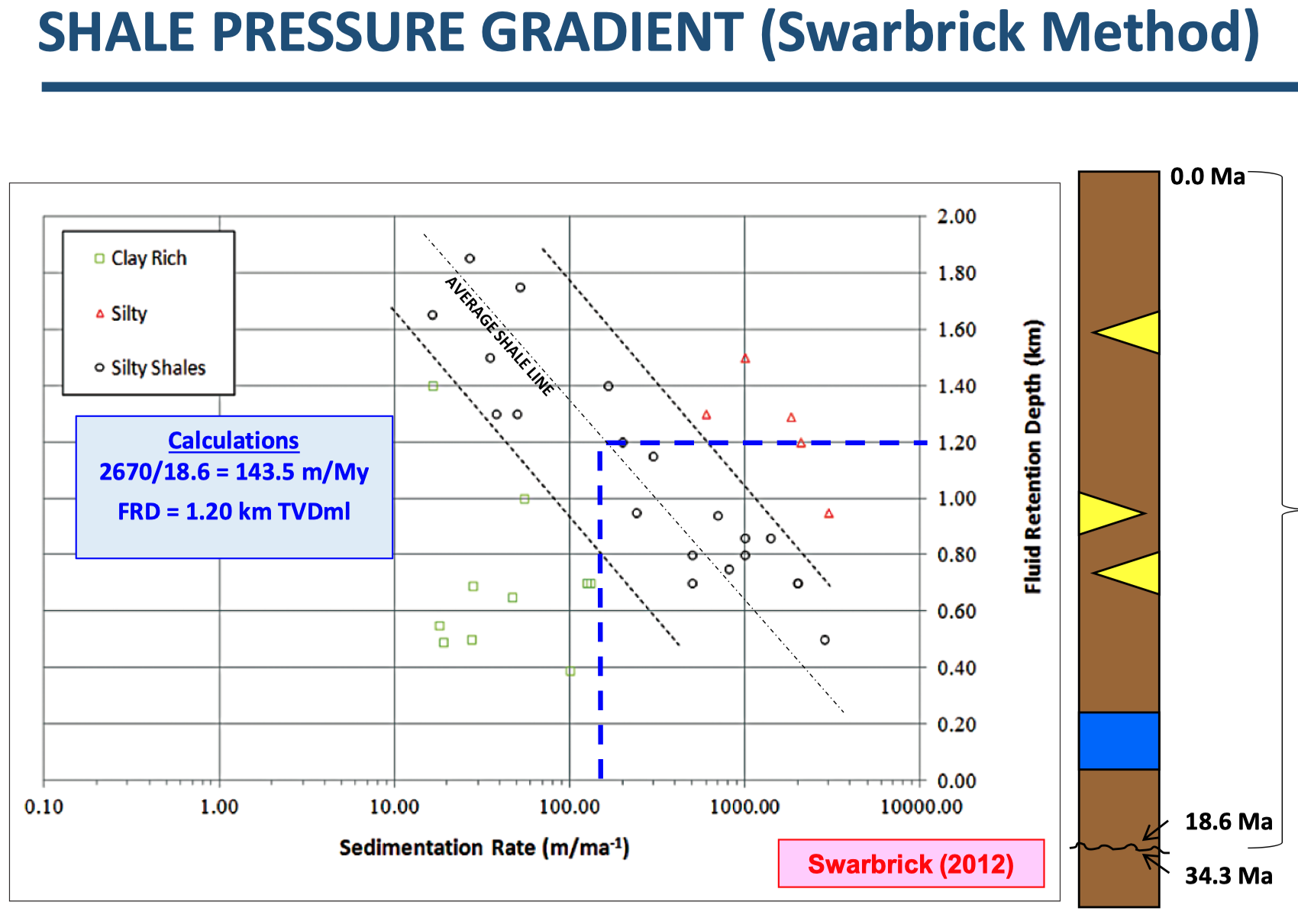
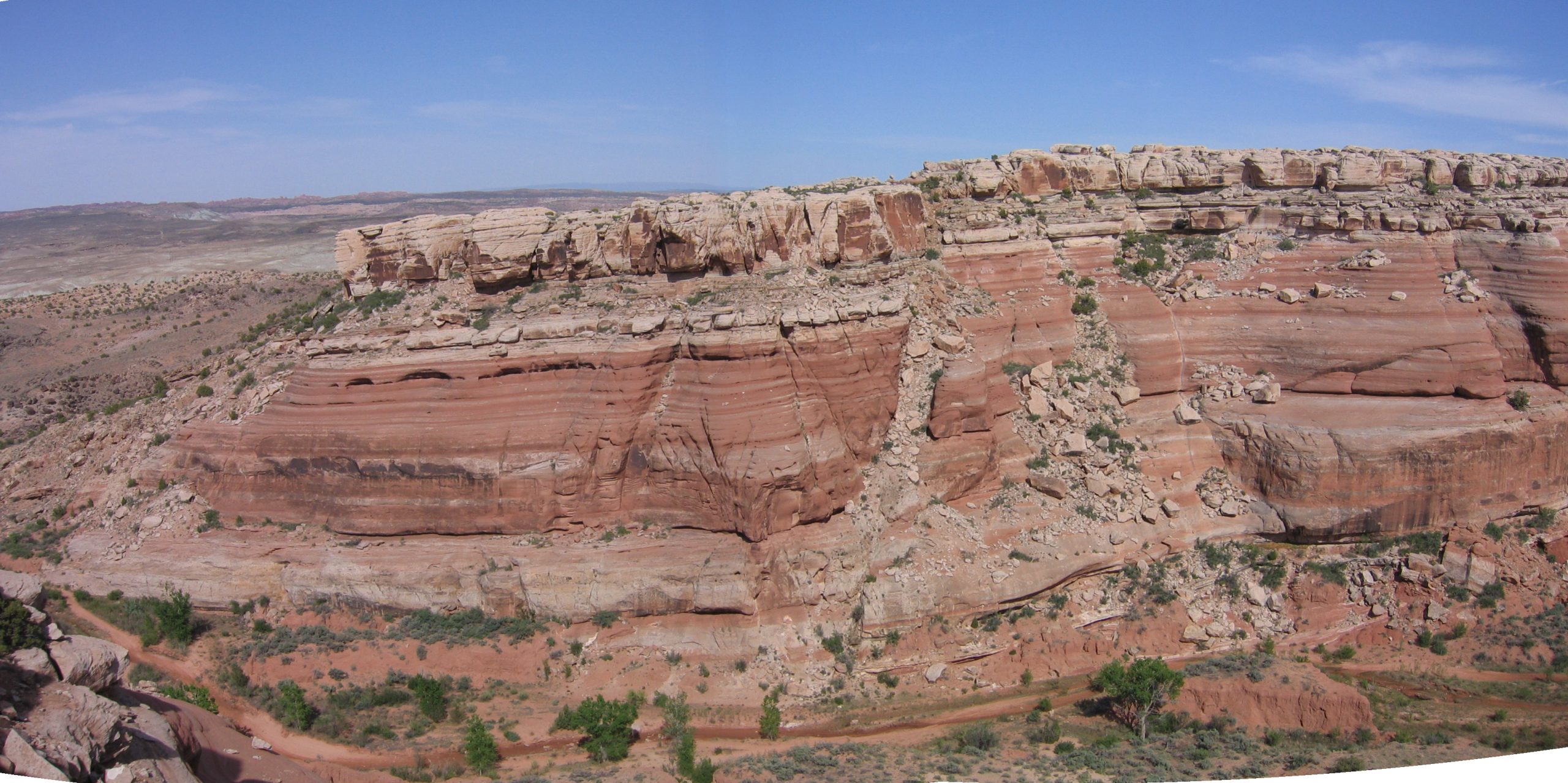
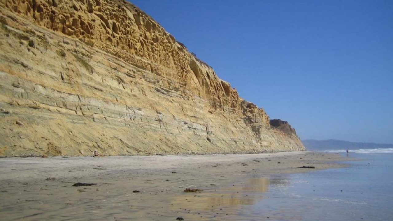
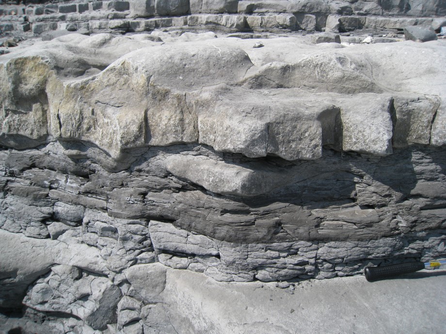
The aim of this course is to provide an overview of clastic and carbonate depositional settings. Different systems will be analysed in terms of their sedimentary structures, architecture and subsurface character. The first section will focus on clastic settings including aeolian, fluvial and shallow marine and especially the nature of the preserved sand bodies in the subsurface. The second section will explore the diverse topic of carbonate depositional settings, including the ranges of carbonate textures and facies that can be preserved and the different types of porosity. Each section will incorporate case studies, exercises and core examples.

Duration and Logistics

Classroom version: 3 days including a mix of lectures and exercises. The course manual will be provided in digital format and participants will be required to bring along a laptop or tablet to follow the lectures and exercises.

Virtual version: Three, 3.5 hour online sessions presented over 3 days. Digital course notes and exercises will be distributed to participants before the course.

Level and Audience

Fundamental. The course is largely aimed at geoscientists who are working on subsurface projects where a wide-ranging understanding of both clastic and carbonate depositional systems is required.

Objectives

You will learn to:

  1. Recognise different clastic environments of deposition including fluvial, aeolian deltaic and shallow marine.
  2. Recognise different sedimentary structures and sedimentary architectures.
  3. Understand the types of sand bodies and associated stacking patterns that are preserved in clastic depositional settings.
  4. Describe the heterogeneities in subsurface clastic reservoirs that can impact fluid flow.
  5. Appreciate how carbonates are classified and different carbonate settings are identified.
  6. Frame the main types of carbonate platform types and corresponding deposits.
  7. Understand the wide range of carbonate textures and facies that make up carbonate reservoirs.
  8. Recognise the different types of porosity and the impact of these on reservoir quality.

Plays, Prospects and Petroleum Systems, Wessex Basin, Dorset, UK (G054)

Tutor(s)

Jonathan Evans: Director, GeoLogica; Chair of Trustees, Lyme Regis Museum.

Overview

This course will illustrate the processes of play analysis and prospect evaluation using the geology of the Wessex Basin and outcrops of the Jurassic Coast of Devon and Dorset. The course will assess the elements of a working petroleum system including reservoir, source, seal and trap in the context of the Wytch Farm oilfield. Participants will have the opportunity to study a wide range of clastic and carbonate depositional systems, in addition to varying structural concepts, and visit two producing oil fields.

The manual will be provided in digital format and you will be required to bring a laptop or tablet computer to the course.

Duration and Logistics

A 5-day field course comprising fieldwork (70%) and classroom exercises (30%). The course will be based in Weymouth and transport will be by coach.

Exertion Level

This class requires an EASY exertion level. Outcrop access is easy with short walks of 1-2 km mostly across sandy beaches. Some field stops have more irregular terrain, in the form of pebbly and rocky beaches.

Level and Audience

Fundamental. The course is intended for junior-mid level geoscientists who are working in exploration as well as development and want a broad overview of key petroleum systems concepts or the chance to revise the key themes. The course would also be of value to reservoir engineers wanting to appreciate the role of, and subsurface data analysed by, the geological team.

Objectives

You will learn to:

  1. Understand the elements required in a working petroleum system and the concept of play analysis.
  2. Create play fairways maps based on fieldwork and published data.
  3. Examine the process of prospect evaluation and volumetric assessment including probability of success.
  4. Rank prospects based on the different play elements.
  5. Perform simple resource assessment and exploration risk analysis.
  6. Identify source rocks, how they form and what makes a good source rock.
  7. Compare different reservoir rocks, including sandstones and chalk, to work out how they were deposited and what controls the key reservoir properties of porosity and permeability at different scales.
  8. Describe different seals and flow barriers both above and within the reservoir intervals.
  9. Work with different types of subsurface data, as part of a team, and measure what scale of information they provide e.g. seismic, well logs, core, well tests, production tests.
  10. Analyse a series of local prospects and establish the geological chance of success.
  11. Assess the stages of a subsurface project from exploration through to development and production.
  12. Appreciate the different drilling and production technology in relation to the different reservoir types and project requirements.

Integrating Teams on the Rocks of the Wessex Basin, Dorset, UK (G056)

Tutor(s)

Jonathan Evans: Director, GeoLogica; Chair of Trustees, Lyme Regis Museum.

Overview

Proper integration of teams and disciplines is increasingly important in the modern energy industry. Ensuring all staff, technical, managerial and non-technical, understand the roles, concepts and language used by various disciplines as well as their requirements for data is critical for cooperation, collaboration and business success. This short course uses field observations and discussion at outcrops within the Wessex Basin to facilitate a deeper understanding of others’ roles as well as providing a refresher/reminder of the fundamental importance of rocks and the data they can provide to energy provision. The Wessex Basin provides a classic example of a working petroleum system with easily accessible outcrops to illustrate source rocks, reservoirs and trapping structures. In addition, the area also provides insights into new energy and carbon reduction methods that rely on a solid understanding of the subsurface.

Duration and Logistics

A 2-day field course in Dorset. For in-house provision the course can be extended or shortened depending on a company’s requirements.

Exertion Level

This class requires an EASY exertion level. Hikes are generally 1-2 km in length, on sandy and rocky beaches, coastal paths and with some irregular terrain.

Level and Audience

Fundamental. The level of the trip however, can be tailored to cater for the target audience: subsurface teams, integrated project teams or raising awareness for a generalist audience.

Objectives

Your team will learn to:

  1. Appreciate what elements are required for a working Petroleum System.
  2. Identify source rocks, how they form and what makes a good source rock.
  3. Compare different reservoir rocks, including sandstones and chalk, to work out how they were deposited and what controls the key reservoir properties of porosity and permeability at different scales.
  4. Understand what different types of subsurface data measure and what scale of information they provide e.g. seismic, well logs, core, well tests, production tests.
  5. Describe different seals both above and within the reservoir intervals.
  6. Understand the Petroleum Geology of the Wessex Basin including the giant Wytch Farm oilfield.

Best Practices in Pore Pressure and Fracture Pressure Prediction (G043)

Tutor(s)

Richard Swarbrick: Manager, Swarbrick GeoPressure.

Overview

This course presents best practices in how data and standard techniques are combined to generate meaningful pore pressure (PP) and fracture pressure (FG) estimates from log, seismic and drilling data, and to use them to develop pre-drill predictions. The limitations are addressed, along with common pitfalls, leading to an understanding of the uncertainty and risk associated with PP and FG prediction.

The course begins by showing the types and reliability of subsurface data used to inform current knowledge, which will also calibrate PP and FG predictions at a remote location. Standard approaches to PP and FG prediction techniques are taught, with careful attention to where these have limitations on account of subsurface environment (thermal, tectonic) and data quality. A new approach to PP prediction using shales is taught as an independent guide to expected PP, especially valuable where only seismic data are available. Prediction of FG is taught by showing how to determine overburden stress and apply standard relationships, including new approaches with PP-stress coupling.

Duration and Logistics

Classroom version: A 2-day classroom course comprising a mix of lectures and discussion (90%) and exercises (10%). The manual will be provided in digital format, and participants will be required to bring a laptop or tablet computer to follow the lectures and exercises.

Virtual version: Four 3.5-hour interactive online sessions presented over 2 to 4 days. A digital manual and exercise materials will be distributed to participants before the course. Some reading and several exercises are to be completed by participants off-line.

Level and Audience

Intermediate. Intended for exploration and development geoscientists, petrophysicists, operations staff and drilling engineers. Familiarity with oilfield data and drilling practices is required. Experience shows that mixed classes of geoscientists and engineers benefit particularly from the discussions and sharing of approaches in this multi-disciplinary area of work.

Objectives

You will learn to:

  1. Distinguish the different types and quality of data that populate pressure-depth and EMW-depth plots for display of pressure predictions and calibration data in well planning.
  2. Use best practice to create PP estimations and predictions from seismic, log and drilling data using standard porosity-based techniques, and from modelling geological systems.
  3. Use best practice to create FG estimations and predictions by generating an overburden and establishing its relationship with FG and PP.
  4. Communicate Min-Expected-Max predictions effectively to both geoscience and engineering/operations staff involved in well planning.

Natural Fractures (Faults and Joints): Quantification and Analysis, Somerset, UK (G033)

Tutor(s)

Mark Bentley: TRACS International Consultancy and Langdale Geoscience.

Overview

This course will explore superb exposures of fault and joint systems within the Triassic/Lower Jurassic of the East Bristol Channel and Central Somerset Basins, focusing on 3-D seismic scale fault systems, including a variety of fracture geometries, fabrics and networks. Field analysis will be supported by materials on stress, strain and fracture development, as well as an analysis of both seal potential and flow potential. Key challenges regarding predicting fracture volumetrics and the challenges of fault seal will be addressed, including how to bridge the gap between outcrop detail and seismic structures and how to represent fractures in reservoir models, whether they be sealing or conductive to flow.

Duration and Logistics

5 days; a mix of field visits (50%) and classroom lectures with exercises (50%).

Exertion Level

This class requires an EASY exertion level. Somerset is quite comfortable in the spring and early summer, with temperatures of 5–20°C (40–65°F) and occasional rain showers. Field stops require short walks along coastal paths, beaches and wave cut platforms. The longest walk is <4km (2.5 miles). Field stops are all at approximately sea level and some are tide dependent. Transport will be by coach.

Level and Audience

Fundamental. The course is designed for geoscientists, petrophysicists, reservoir engineers and well engineers. Ideally structured for groups working in multi-discipline, asset-based teams with structurally complex reservoirs wishing to understand fracture properties and their impact on fluid flow.

Objectives

You will learn to:

  1. Characterize fracture systems and geometries in the subsurface.
  2. Quantify fault properties, including sealing capacity and threshold pressure.
  3. Quantify open natural fracture properties.
  4. Address modeling challenges for fracture type and fracture property distribution.
  5. Represent fractures (both faults and joints) in reservoir simulations.
  6. Evaluate risk and uncertainty associated with fracture modeling.
  7. Evaluate the impact of fractures on well planning and seal integrity.

Sand-rich Turbidite Systems: From Slope to Basin Plain, Pyrenees, Spain (G016)

Tutor(s)

Henry Pettingill: Senior Associate, Rose & Associates LLP; President, Geo Ventures International Inc.

Overview

This course in the Central Pyrenees will visit spectacular outcrops of Eocene deep marine clastics in the confined mini-basin settings of the Ainsa and Jaca basins. Shelf-slope-basin relations are examined in detail and reveal features such as ponding in sub-basins, system architecture and reservoir stacking patterns. Identification of facies types is emphasized at both reservoir and exploration prospect scales. The use of the outcrops as analogs for producing oil and gas fields is discussed and 3-D models of the basin infill and deep marine deposition will be shown. Attendees are encouraged to bring their own data for discussion as either presentations or as posters.

Duration and Logistics

A 6-day field course comprising a mix of outcrop examination and discussion (70%), core examination (15%) and supporting classroom lectures (15%). The course is conducted in the Central Pyrenees of northern Spain, with attendees arriving in and departing from Barcelona, Spain. The course materials are supplied as a short, printed field guide with supporting lecture material provided in digital format – if you wish to access this while on the course you will need to bring a laptop or tablet computer.

Level and Audience

Advanced. Suitable for geoscientists and reservoir engineers seeking to understand deepwater clastic reservoir distribution, prediction and compartmentalization. Appropriate for asset teams looking to develop a common understanding of their deepwater clastic reservoirs.

Exertion Level

This class requires an EASY exertion level. Travel between outcrops will be by small coach and there are several short hikes of 2–3km (1.2–1.8 miles) over uneven ground, but nothing overly strenuous. The weather can be variable and ranges from hot and dry to cold and very wet, with fall temperature ranges of 5–30°C (40–85°F), so please be prepared. Field days start around 9am and finish at 6–7pm. (Please note that meals are taken rather late by North American and northern European standards.)

Objectives

You will learn to:

  1. Recognize genetically linked facies deposited by submarine gravity flow processes within a partitioned foredeep, from slope to basin plain.
  2. Identify the transitions between the various components of the system (channel, lobe, etc.), their controls and predictive aspects.
  3. Characterize the geometry and scale of sand bodies and their stacking patterns in outcrop and compare with reservoir units in analogous subsurface settings.
  4. Assess the relation between syndepositional tectonics and partitioned mini-basins that act as receiving basins.
  5. Assess and predict the control of sand body geometry and reservoir architecture on reservoir production characteristics.
  6. Assess high-frequency cyclicity recorded in the sediments and relate these patterns to intrinsic and extrinsic basin controls.
  7. Apply predictive models for the infill of facies and stacking patterns based on the interplay between mini-basin geometry/development and sediment infill.

Workflows for Seismic Reservoir Characterization (G004)

Tutor(s)

Patrick Connolly: Director, Patrick Connolly Associates; Visiting Lecturer, University of Leeds, UK.

Overview

This course will provide participants with the skills needed to design and implement workflows for seismic reservoir characterization using established best-practice and emerging technology. The course covers seismic conditioning, colored inversion, AVO theory including elastic and extended elastic impedance, DHIs, seismic net pay, well ties, rock physics and deterministic and probabilistic inversion, including the application ODiSI.

Duration and Logistics

A 4-day classroom course comprising a mix of lectures with examples (70%) and laptop-based exercises and discussion (30%). The manual will be provided in digital format and participants will be required to bring a laptop or tablet computer to follow the lectures and exercises.

Level and Audience

Advanced. Intended for practicing seismic interpreters. Participants should have a basic knowledge of the seismic method, including acquisition and processing, with a minimum of three years working with seismic data. However, the subject matter of this course, AVO and inversion, is covered from basic principles.

Objectives

You will learn to:

  1. Appreciate the benefits of colored inversion – how and why it works and how to get the best results from a colored inversion application.
  2. Understand the relationships between reflectivity and impedance, and between time and frequency.
  3. Understand the model for AVO measurements and the difficulties in making accurate AVO measurements.
  4. Understand the concepts behind AVO analysis, including intercept-gradient crossplots and the theoretical relationship between elastic and AVO properties.
  5. Optimize AVO products for subsequent characterization work and create seismic products that correlate with specific reservoir properties.
  6. Appreciate the risks of using attributes with no physical relationship with the desired objective.
  7. Appreciate the limitations of the seismic net pay method and to know when it is, and is not, applicable.
  8. Understand the principles and pros and cons of deterministic and probabilistic inversion and how to select the appropriate inversion strategy for any given problem.

Women in Energy Field Experience: The Role of Salt in Hydrocarbon Exploitation, Energy Storage and Carbon-reduction Mechanisms, Paradox Basin, Utah and Colorado (G084)

Tutor(s)

Kate Giles: Lloyd A. Nelson Professor, University of Texas at El Paso; Consulting Geologist.

Cindy Yeilding: NE Director, Denbury Inc.

Overview

This course is aimed exclusively at women working in the energy industry, particularly in the geoscience, geotechnical and engineering fields. The primary technical goal is to provide a widely applicable introduction to the interrelationship between sedimentation and structural geology with a particular focus on salt tectonics and salt-sediment interaction. The geology is examined with reference to energy production, including hydrocarbon exploration and production, along with discussions around energy transition topics (CCUS, geothermal, hydrogen and energy storage). While the technical aspects are paramount, the course is also designed to provide networking and professional development opportunities. Evening discussions and activities will allow for exchange of ideas and experiences in a supportive and open atmosphere.

Duration and Logistics

A 5-day field course starting and finishing in Grand Junction, Colorado, comprising a mixture of field exercises, activities and networking.

Level and Audience

Fundamental. This course requires a basic understanding of geoscience and will suit those working in the geoscience, geotechnical and engineering fields. The aim is to facilitate knowledge and experience exchange among the participants, so is open to women from a very wide range of experience levels.

Exertion Level

This course requires a MODERATE exertion level. There will be hikes to outcrops of up to 6.5km (4 miles) round trip. Some of these will encounter uneven and rocky ground with some short, steep inclines. The climate in southern Utah is typically warm to hot and dry with temperatures up to 37.5°C (100°F) and the elevation is between 1,250–1,500m (4,000–5,000 ft).

Objectives

You will learn to:

  1. Describe the regional stratigraphy and principal structural features of the Paradox Basin, Utah.
  2. Characterize and interpret controls on Paradox Basin salt-related structures and key features of passive diapiric systems, including halokinetic sequences, caprock development, non-evaporite stringers / inclusions, welds, megaflaps, counter-regional faults, radial faults and burial wedges.
  3. Examine stratal geometries and halokinetic sequences and how these relate to intervals of salt inflation / evacuation and sediment flux.
  4. Assess the controls on basin fill architecture, fluid flow and deformation within the Paradox Basin and compare this to analogous salt basins worldwide.
  5. Understand the importance of salt basins to the energy industry for hydrocarbon production.

Structural Styles and Fault Characterization in Exploration and Production, Moab, Utah (G078)

Tutor(s)

Russell Davies: Director, Redlands Fault Geological Consulting LLC.

Overview

This field course utilizes outstanding exposures of faults, fault rocks and stratigraphy in Colorado and Utah to examine seismic and subseismic scale fault geometries, fault zone architecture and controls on cross-fault flow. The aim of the course is to improve the understanding of uncertainties in the mapping of complex fault zones and the processes that create potential seals and compartmentalization in reservoirs in the subsurface for oil and gas, as well as CO2. Field exercises complement classroom lectures on the interpretation of faults, seal assessment and associated risks. Group exercises are included as prospect interpretation of compartmentalization from outcrop exposures.

Duration and Logistics

A 7-day field course with a mixture of outcrop examination and discussion (70%) and supporting classroom lectures (30%). Exercises on the outcrop are designed to apply common methodologies for fault seal analysis with observed fault zone characteristics.

Level and Audience

Intermediate. This course is suitable for geologists, geophysicists and reservoir engineers engaged in the interpretation of faults and the assessment of fault seal in reservoirs for exploration, development and CO2 containment.

Exertion Level

The field component of this course requires a MODERATE exertion level. There will be some short hikes to outcrops (no more than 3.5 miles / 5.6km round trip), some over uneven and rocky ground with some short, steep inclines no greater than 700 feet (200 meters). The climate in southern Utah during the spring and fall is variable with temperatures from 50°F (10°C) to hot and dry up to 100°F (38°C). The elevation is between 4,000 and 5,000 feet (1200 to 1500 meters).

Objectives

You will learn to:

  1. Describe the regional geologic framework of the field area, the main stratigraphic units and the principal structural features.
  2. Characterize the mechanisms of faulting, fault propagation and the controls on the size, distribution and population of normal faults.
  3. Observe deformation and faults in outcrop to constrain likely structural and fault geometries in the subsurface.
  4. Characterize common trapping mechanisms and seal potential of fault rocks.
  5. Examine and assess fault rock properties and evidence of fluid flow at outcrop scale to better understand subsurface flow in reservoir and fault rocks.
  6. Establish trap and seal controls.
  7. Perform juxtaposition analysis and fault rock distribution mapping (SGR and CSF / SSF).
  8. Employ and interpret triangle diagrams.
  9. Understand key simulation techniques and modelling of faults.

Reservoir Characterization of Deepwater Systems, San Diego, California (G046)

Tutor(s)

Rene Jonk: Director, ACT-Geo Consulting and Training; Honorary Professor, University of Aberdeen.

Overview

Submarine canyons and deepwater channels are the primary conduits for the transfer of coarse sediments from the shelf to deep-water fans and they are today major targets for petroleum exploration. Southern California has had a long and complex geologic history that has involved many episodes of deepwater sedimentation in a variety of settings ranging from the Paleozoic passive margin of the North American craton to Mesozoic forearc and arc settings to Cenozoic transform, pull-apart, and continental borderland basins. These settings feature deep-water deposits in which both large and small submarine channels and fans played major roles as sediment transport routes and sites of sedimentation.

Duration and Logistics

6 days; a mix of outcrop examination and discussion (70%) and supporting classroom lectures (30%).  The field course is conducted in southern California along the coastline north of San Diego.

Level and Audience

Advanced. Geologists, geophysicists, and petroleum engineers working on deep water reservoirs from exploration to production.

Exertion Level

This class requires a MODERATE exertion level. Access to the coastal cliff outcrops is via sandy beaches, with most walks under 2 km. Some shallow wading on a sandy beach is also necessary in order to visit some outcrops.

Objectives

You will learn to:

  1. Review deepwater lithofacies nomenclature and definitions, common lithofacies associations, and interpret lithofacies in outcrops and cores.
  2. Interpret environments of deposition (EoD’s) and related reservoir architecture, lithofacies associations, and diversity.
  3. Interpret sequence stratigraphic surfaces in outcrop, logs, and seismic in DW settings and related to vertical stacking of facies.
  4. Use core and well-logs to interpret EoD’s.
  5. Evaluate reservoir geometry and connectivity in different EoD’s.
  6. Recognise the Do’s and Don’ts of using outcrops as reservoir analogs
  7. Apply outcrop information as analog for reservoir model building
  8. Evaluate seismic response, including geometry, facies, and acoustic response in deepwater EoD’s
  9. Apply the criteria for the identification of Composite Sequences, Sequence Sets, and Depositional Sequences and their components in outcrops, cores, well logs, and seismic
  10. Use interpretation and mapping techniques for cores, well-logs, and seismic lines in deepwater settings, from Exploration to Production business scales
  11. Apply criteria and mapping strategies for play elements in deepwater depositional settings
  12. Identify and map play fairways in deepwater settings.